Conversatorio (online): Cartografía Patrimonial

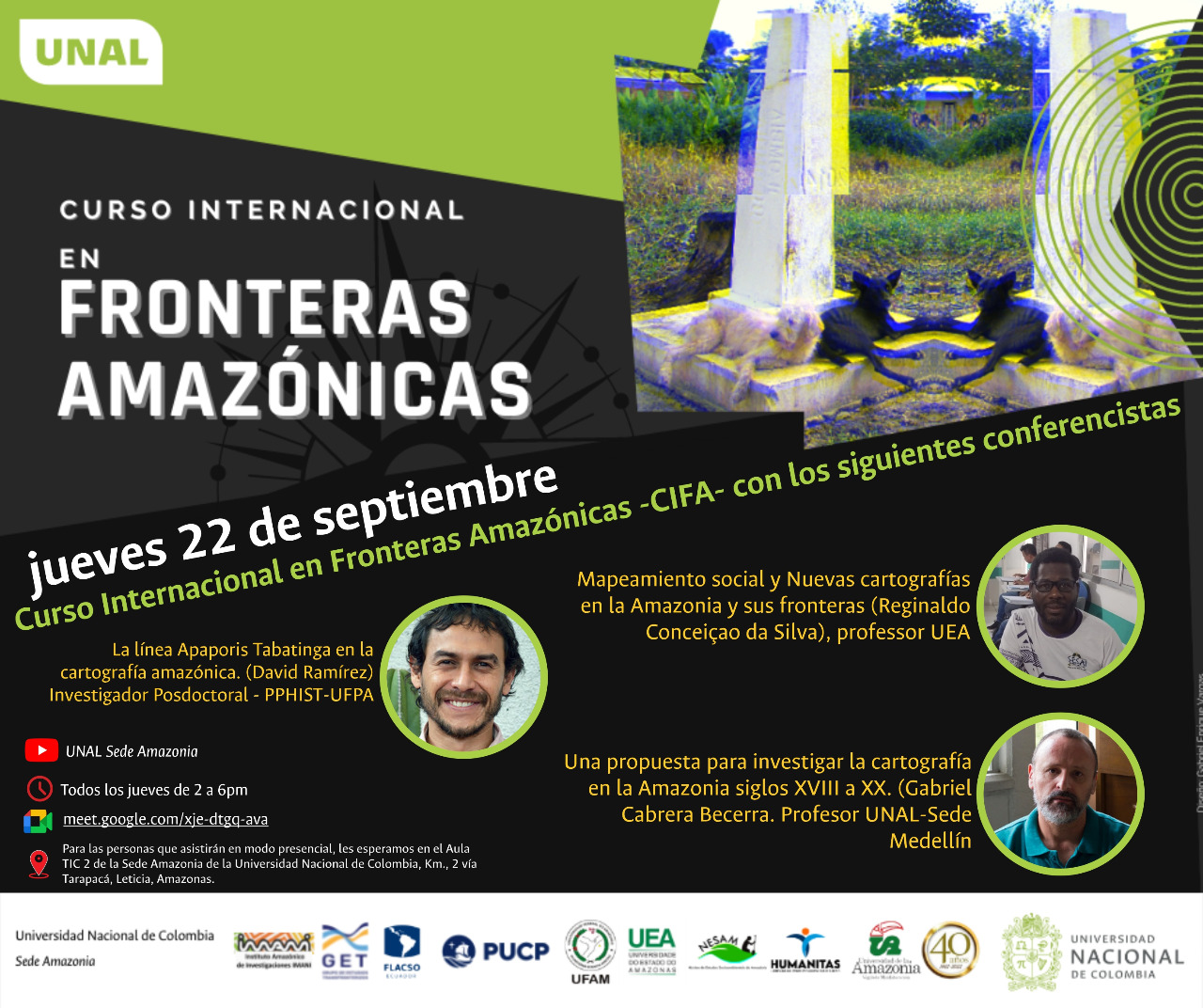
Este 18 de mayo el Instituto Distrital de Patrimonio Cultural-IDPC realizará el conversatorio ‘Cartografía Patrimonial’ a las 9:15 a.m. en el Facebook del IDPC.

En esta charla podremos entender que los mapas ya no son exclusividad de unos pocos, sino que se han convertido en herramientas de democratización y visibilización de aquello que antes parecía irrelevante.

Los panelistas invitados 

  • Juan Carlos Bohórquez: Arquitecto y planificador urbano con 24 años de experiencia en formulación de proyectos urbanos para el sector público y privado.
  • Santiago Muñoz Arbeláez: PdD en historia por la Universidad de Yale. Profesor asistente de historia de la Universidad de Texas en Austin y cofundador en Neogranadina.
  • Camilo Escallón: Biólogo. PhD en ecofisiología de organismos. Consultor ambiental en uso sostenible de recursos naturales e investigador en ecología.
  • Martín Bermúdez: Magíster en Economía Ambiental de la Universidad de los Andes. Consultor independiente en estudios ambientales y rurales.

La moderación estará a cargo de Ana Milena Vallejo que es arquitecta, Magíster en Planeación Urbana y Subdirectora de Gestión Territorial del Patrimonio del IDPC.

Mayor información:

https://bogota.gov.co/mi-ciudad/cultura-recreacion-y-deporte/el-18-mayo-conversatorio-cartografia-patrimonial-en-el-facebook-idpc

Exposición: Terra Firme. Mapas y visitas del Nuevo Mundo – Siglos XVI – XIX

El próximo sábado 6 de mayo a las 5:00p.m en el CFCE (@cfcecartagena – Centro de Formación de la Cooperación Española en Cartagena de Indias, Colombia) se inaugura la exposición «𝙏𝙚𝙧𝙧𝙖 𝙁𝙞𝙧𝙢𝙚. 𝙈𝙖𝙥𝙖𝙨 𝙮 𝙫𝙞𝙨𝙩𝙖𝙨 𝙙𝙚𝙡 𝙉𝙪𝙚𝙫𝙤 𝙈𝙪𝙣𝙙𝙤 – 𝙎𝙞𝙜𝙡𝙤𝙨 𝙓𝙑𝙄 – 𝙓𝙄𝙓». Entrada gratuita.

Este evento contará con una selección de mapas grabados y monedas de los siglos XVI al XIX, se ofrecerá un recorrido histórico en el que los visitantes conocerán qué fue la “Tierra Firme” en el proceso de cohesión geoespacial del Nuevo Mundo y verán cómo este último se formó como un continente en la imaginación geográfica moderna.

Esta exposición se realiza con motivo del arribo a Colombia del buque escuela de la Armada española, Juan Sebastián de Elcano. El buque llegará a Cartagena este 5 de mayo.

Organizan: Embajada de España en Colombia y @proyectobachue

Convocatoria: Imago Mundi – The International Journal for the History of Cartography

La revista Imago Mundi: The International Journal for the History of Cartography abre convocatoria laboral para Editores asistentes y Bibliógrafo, para aplicar es necesario tener dominio del idioma inglés y acceso óptimo a internet. Para solicitar la postulación se deberá enviar lo requerido antes del 28 de febrero de 2023. Para recibir las postulaciones se deberán tener en cuenta los siguientes requisitos y condiciones:

Para el rol de Editor asistente se requieren dos personas, quienes iniciarían en febrero de 2023:

  • Each Assistant Editor will receive a stipend of £2,000 annually. While the position is open to all applicants, we anticipate that it will be of most interest to graduate students or early career professionals with an interest in the history of cartography who wish to learn about academic publishing.  
  • The Assistant Editors will report to the journal editor(s). Responsibilities include editorial and administrative tasks, with primary responsibility for correspondence regarding manuscript submissions with authors and reviewers, and administrative correspondence, including with Imago Mundi’s publisher and editorial team and helping ensure that the team meets publication goals and deadlines. Depending on interests and skills, additional contributions may include helping with initial manuscript review and copyediting, image editing, social media and outreach, and projects decided with the journal’s editors. We anticipate that the work will demand on average 4-6 hours/week. 
  • Fluency in English is required; additional language skills are welcome. Applicants must have internet access and be proficient in basic computer skills.
  • We invite interested applicants to send an email explaining their interest in and experience with the history of cartography and publishing industries, and a short CV (no more than 5 pages), as well as the names of two references. References may be academic or professional. 
  • Applications and queries can be sent to editor.imagomundi@gmail.com . The editors will schedule online meetings/interviews with finalists on a rolling basis, until the positions have been filled. Consideration of applications will begin on February 28, 2023. 

Para el rol de Bibliógrafo se requiere una persona:

  • The International Journal for the History of Cartography is recruiting a second individual who, along with Colin Dupont (KBR, Royal Library of Belgium), will prepare the bibliography and indexes which are part of the journal’s offerings.
  • The bibliography is global in scope, with entries in many languages. Applicants with competencies in Chinese are especially welcome. The position would be well suited to a librarian or individual with research experience in the history of cartography, but is open to all. The position comes with an annual stipend of £250.
  • The journal is published with Taylor and Francis twice annually, in January and July, in paper and online editions, with contributions to the bibliography in each issue. The editorial team works remotely and communicates primarily via email.
  • The successful candidate would gather, format, and index the newest publications, working closely with Colin and the journal’s national representative and editors. The bibliographers submit a new list of sources twice a year and review proofs of the bibliography.
  • Prospective applicants should send a brief cv and an email detailing their interest to editor.imagomundi@gmail.com For full consideration, please submit your application by February 28, 2023. Questions can also be directed to that address.

Hoy: Inicia curso internacional en fronteras amazónicas (los jueves 2-6pm Colombia)

Jueves 22 de Septiembre 2022

Mapeamiento social y Nuevas cartografías en la Amazonía y sus fronteras (Reginaldo Conceicao da Silva), professor UEA

La línea Apaporis Tabatinga cartografía amazónica. (David Ramirez) Investigador Posdoctoral – PPHIST-UFPA

Una propuesta para investigar la cartografía en la Amazonía siglos XVIII a XX. (Gabriel Cabrera Becerra Profesor UNAL -sede Medellín.

http://meet.google.com/xje-dtgq-ava